

You can find on this page the Indonesia trains map to print and to download in PDF. The Indonesia railways map presents the rail network and shows high speed rails routes of Indonesia in South Eastern Asia.

The Indonesia rail map shows all the railway stations and lines of Indonesia trains. This train map of Indonesia will allow you to easily travel by train in showing the major rail routes and high speed rail routes of Indonesia in South Eastern Asia. The Indonesia rail map is downloadable in PDF, printable and free.
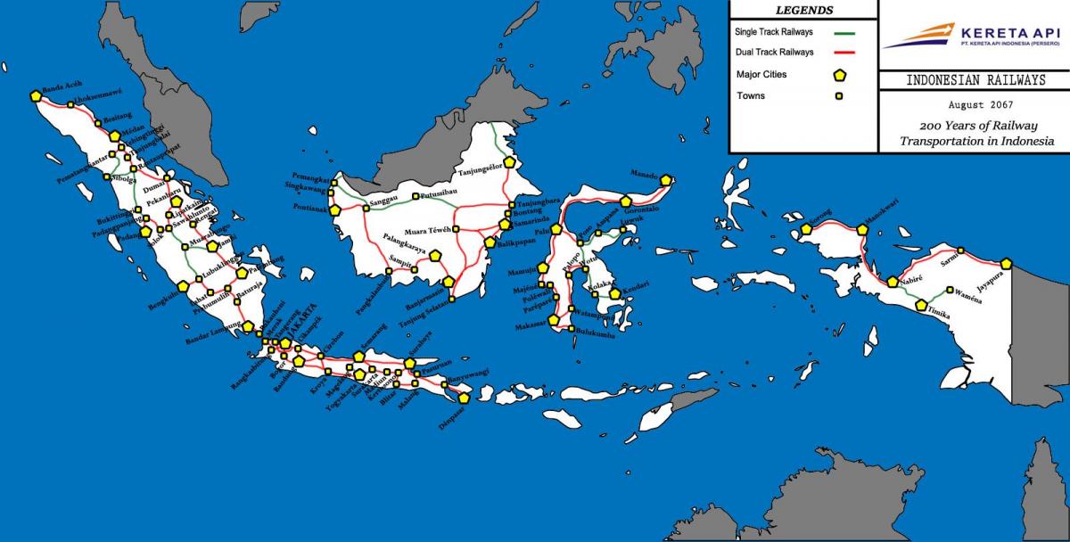
Most rail transport in Indonesia is located on the island of Java, which has two major rail lines that run the length of the island, as well as several connecting lines. The island of Sumatra has three (soon to be four) unconnected railway lines in the northernmost province of Aceh, North Sumatra (the area surrounding Medan), West Sumatra (Padang and its environs), and South Sumatra and Lampung as you can see in Indonesia rail map. Indonesia railways are operated by the state-owned PT Kereta Api, and the newly formed PT Kereta Api Jabotabek, operating the commuter lines in the Jakarta metropolitan area. The infrastructure is state-owned, and the companies pay a fee for the usage of the railway lines.
The first railway track in Indonesia was laid between Semarang and Tanggung—both in Central Java—on 17 June 1864 by the Dutch colonial government. The line opened in 1867 and later continued to Yogyakarta as its shown in Indonesia rail map. Indonesia rail gauge is 1,067 mm (3 ft 6 in), although 1,435 mm (4 ft 8 1⁄2 in) and 750 mm (2 ft 5 1⁄2 in) lines previously existed. New construction in Aceh has the 1,435 mm (4 ft 8 1⁄2 in) gauge. Most of the Jakarta metropolitan area is electrified at 1500 V DC overhead. Various narrow gauge industrial tramways operate in Java and Sumatra, serving the sugarcane and oil palm industries. The only urban rail network in Indonesia is KRL Jabodetabek. However, Jakarta Mass Rapid Transit is scheduled to open 2016 if all goes well. Together with Transjakarta BRT, they comprise the rapid transit network.
Most of active railway network in Indonesia mainly is operated in Java and connecting main cities in the island; from Merak in western edge to Banyuwangi in eastern edge as its mentioned in Indonesia rail map. However several unconnected railway networks built during Netherlands East Indies exist in Sumatra, such as the ones connecting Banda Aceh-Lhokseumawe-Besitang-Medan-Tebingtinggi-Pematang Siantar-Rantau Prapat in Northern Sumatra (the Banda Aceh-Besitang section was closed in 1971, but is being rebuilt, as of 2011), Padang-Solok-Bukittinggi in West Sumatra, and Bandar Lampung-Palembang-Lahat-Lubuk Linggau in Southern Sumatra. The railway system in Java is more or less a passenger-oriented system, and there are few freight services, due to the limited capacity of the tracks.