

You can find on this page the Indonesia geographical map to print and to download in PDF. The Indonesia geographic map presents the topography, elevation, rivers, mountains, climate and physical features of Indonesia in South Eastern Asia.

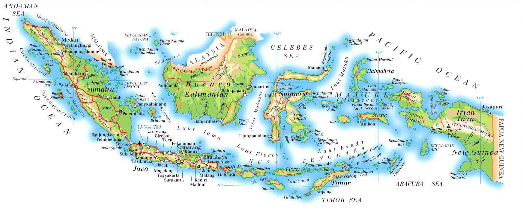
The Indonesia physical map shows landform and geography of Indonesia. This geographical map of Indonesia will allow you to discover physical features of Indonesia in South Eastern Asia. The Indonesia physical map is downloadable in PDF, printable and free.
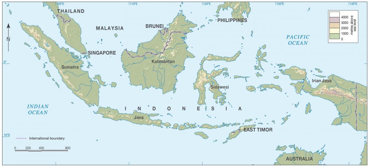
Indonesia is an archipelagic island country in Southeast Asia, lying between the Indian Ocean and the Pacific Ocean. It is in a strategic location astride or along major sea lanes from Indian Ocean to Pacific Ocean as you can see in Indonesia physical map. The country variations in culture have been shaped—although not specifically determined—by centuries of complex interactions with the physical environment. Although Indonesians are now less vulnerable to the effects of nature as a result of improved technology and social programs, to some extent their social diversity has emerged from traditionally different patterns of adjustment to their physical circumstances.
Indonesia is a mix of coastal plains with some mountainous areas within the interior of its islands. For example, the islands of Sumatra, Borneo, and Papua contain the Barisan, Kapuas, and Maoke Mountains as its shown in Indonesia physical map. At 4,884 m (16,024 ft) in height, Puncak Jaya (Mount Jayawijaya) is the highest mountain in Indonesia on the island of New Guinea. Many of the mountainous areas in Indonesia are active volcanoes, such as Mount Merapi on the island of Java.
The geographically fragmented nation of Indonesia consists of over 17,500 islands -- 6,000 of which are inhabited -- strewn throughout the seas and straits between the Indian and Pacific Oceans. Straddling the equator, this exotic archipelago encompasses myriad landforms, such as lowlands, mountains and volcanoes. Included in Indonesia total territory is another 93,000 square kilometers of inlands seas (straits, bays, and other bodies of water) as its mentioned in Indonesia physical map. The additional surrounding sea areas bring Indonesia generally recognized territory (land and sea) to about 5 million square kilometers. The government, however, also claims an exclusive economic zone, which brings the total to about 7.9 million square kilometers.

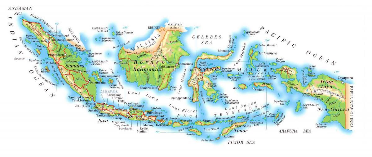
Indonesia topographic map shows the physical features of Indonesia. This topographical map of Indonesia will allow you to discover landforms and geographical of Indonesia in South Eastern Asia. The Indonesia topographic map is downloadable in PDF, printable and free.
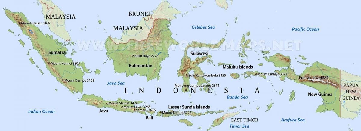
The topography of Indonesia islands varies, but it consists mainly of coastal lowlands. Some of Indonesia larger islands (Sumatra and Java for example) have large interior mountains. Because the 13,677 islands that makeup Indonesia are located on the two continental shelves, many of these mountains are volcanic, and there are several crater lakes on the islands as you can see in Indonesia topographic map. Java alone has 50 active volcanoes. Because of its location, natural disasters—especially earthquakes—are common in Indonesia. On December 26, 2004, a 9.1 to 9.3 magnitude earthquake struck in the Indian Ocean, which triggered a large tsunami that devastated many Indonesian islands.
Most of Indonesia major islands are covered by towering mountain ranges, with numerous peaks reaching above 12,000 feet as its shown in Indonesia topographic map. On Sumatra, the long, narrow Barisan chain stretches some 1,000 miles down the entire length of the western portion of the island. At the tail end of this range in southern Indonesia is the Bukit Barisan Selatan National Park, home to exotic wildlife, such as the endangered Sumatran tiger and rhinoceros. The southern edge of the Barisan Mountains are also home to important cultural and archaeological sites, mainly consisting of megaliths in the shape of humans and animals, some of which may date back to nearly 1,000 B.C.E.
The country of Indonesia has numerous mountains and some 400 volcanoes, of which approximately 100 are active. Between 1972 and 1991 alone, twentynine volcanic eruptions were recorded, mostly on Java. The most violent volcanic eruptions in modern times occurred in Indonesia. Mountains ranging between 3,000 and 3,800 meters above sea level can be found on the islands of Sumatra, Java, Bali, Lombok, Sulawesi, and Seram as its mentioned in Indonesia topographic map. The country tallest mountains, which reach between 4,700 and 5,000 meters, are located in the Jayawijaya Mountains and the Sudirman Mountains in Irian Jaya. The highest peak, Puncak Jaya, which reaches 5,039 meters, is located in the Sudirman Mountains.

The Indonesia elevation map shows the different altitudes of Indonesia. This altitude map of Indonesia will allow you to know where are the highest and lowest regions of Indonesia in South Eastern Asia. The Indonesia elevation map is downloadable in PDF, printable and free.
Elevation extremes of Indonesia are as follow: the lowest point is Indian Ocean 0 m(sea surface level), Wetar Basin in east of Banda Sea at -7,440 m (northwest of Tanimbar Islands & southeast of Ceram Island), where subduction zone is. The highest elevation point is Puncak Jaya (also known as Carstenz Pyramid) 4,884 m as you can see in Indonesia elevation map.
Banda Sea, Bahasa Indonesia Laut Banda, portion of the western South Pacific Ocean, bounded by the southern islands of the Moluccas of Indonesia (Alor, Timor, Wetar, Babar, Tanimbar, and Kai on the south and Ceram, Buru, and Sula on the north). The Banda Sea is divided into two basins separated by a ridge that is surmounted in places by coral reefs. The North Banda Basin is 19,000 feet (5,800 metres) deep, while the South Banda Basin is 17,700 feet (5,400 metres) deep. A volcanic ridge further divides the southern South Banda Basin from the Weber Basin, the deepest in the sea, at some 24,409 feet (7,440 metres). The active volcano, Mount Api, rises from the floor of the southern basin at 14,800 elevation feet (4,500 metres) to 2,200 feet (670 metres) above sea level as its shown in Indonesia elevation map. The clear waters surrounding many islands provide a perfect habitat for spectacular coral reefs.
Puncak Jaya (pronounced [ˈpuntʃaʔ ˈdʒaja]) or Carstensz Pyramid (4,884 m) is the highest summit of Mount Carstensz (/ˈkɑrstəns/) in the Sudirman Range of the western central highlands of Papua province, Indonesia (within Puncak Jaya Regency). Other summits are East Carstensz Peak (4,808 m), Sumantri (4,855 m) and Ngga Pulu (4,863). Other names include Nemangkawi in the Amungkal language, Carstensz Toppen and Gunung Sukarno. At 4,884 metres (16,024 ft) above sea level, Puncak Jaya is the highest mountain in Indonesia, the highest on the island of New Guinea (which comprises the Indonesian West Papua region plus Papua New Guinea), the highest of Oceania (Australian continent), and the 5th highest mountain in political Southeast Asia. It is also the highest elevation point between the Himalayas and the Andes, and the highest island peak in the world. Some sources claim Mount Wilhelm, 4,509 m (14,793 ft), as the highest mountain peak in Oceania, on account of Indonesia being part of Asia (Southeast Asia) as its mentioned in Indonesia elevation map.
The rivers in Indonesia map shows the principal rivers with their names of Indonesia. The rivers map of Indonesia will allow you to find the main rivers which flow in and through Indonesia in South Eastern Asia. The Indonesia rivers map is downloadable in PDF, printable and free.
The majority of Indonesia population lives near water, both on the coast or along rivers and lake shores. Indonesia major rivers do not compare in size or scope to the Mekong or the Yangtze in mainland Asia, but its rivers still play a major role in the country economy and culture. Four of Indonesia longest rivers can be found in the Kalimantan provinces on the island of Borneo: Mahakam, Barito, Kahayan, and Kapuas, which at 710 miles long is Indonesia longest river. Papua New Guinea boasts the second longest river, the Sepik, which is 700 miles long as you can see in Indonesia rivers map. Other major rivers on the island include the Fly, Mamberamo, and Pulau. Sumatra longest rivers are the Musi and Batang Hari.
More than two-thirds of the 300 species of fish identified in the Kapuas river have a high economic value, supporting a thriving fishing industry. The Kapuas River is a major transportation artery connecting the Borneo center with its western coast: its massive width and depth support intensive cargo and passenger shipping along most of the river length. Logging and timber rafting also occur along the river. The Musi river has been dredged to allow large ships to navigate as far as Palembang, a major port city facilitating the export of petroleum, rubber, and coal. The Fly River delta as its shown in Indonesia rivers map is studded with large islands covered with thick, fertile alluvial soil. Coconut palm, breadfruit, plantain, sago palm, and sugarcane are grown abundantly. The Mahakam River basin contains numerous lakes, producing annual catches of up to 35,000 metric tons. This area is the second most productive hydrocarbon basin in Indonesia, containing nearly three billion barrels of oil and thirty trillion cubic feet of gas reserves.
The Sepik River basin as its mentioned in Indonesia rivers map includes swamplands, tropical rainforests, and mountains. Biologically, its river system is possibly the largest uncontaminated freshwater wetland system in the Asia-Pacific region. Largely an undisturbed environment, there are no major urban settlements, mining or forestry activities in the river catchment area. The Mahakam River is home the Irrawaddy freshwater dolphin, a critically endangered species, and is also an important breeding and resting place for 298 species of bird, including 70 protected and five endemic species. Japan held the Sepik River area throughout most of World War II. The area was the site of a battle between Japan and Australia in 1945.

The mountains in Indonesia map shows the principal mountains with their names in Indonesia. The mountains map of Indonesia will allow you to find the main mountains ranges and highest mountains of Indonesia in South Eastern Asia. The Indonesia mountains map is downloadable in PDF, printable and free.
Indonesia Sudirman Range Mountains is the location of the four tallest mountains in the country. Standing at a height of 16,024 feet (4,884 meters) tall, Puncak Jaya is the tallest mountain in all of Indonesia and Greater Oceania as you can see in Indonesia mountains map. After Puncak Jaya, the next three tallest mountains are Sumantri standing at 15,978 feet (4,870 meters) tall, Ngga Pulu standing at 15,951 feet (4,862 meters) tall and Carstenz East standing at 15,814 feet (4,820 meters) tall. Puncak Jaya, which is also called Carstensz Pyramid, had its snow covered peak first sighted by Dutch explorer Jan Carstenzoon in 1623, although it took over 200 years before anyone else could confirmed what he saw since no one in Europe believe that snow could be at the equator of the Earth. This was finally confirmed in 1909 when Hendrik Albert Lorentz, a Dutch explorer, reach the snowfield of Puncak Jaya with the help of several Dayak Kenyah porters.
The Jayawijaya Mountains Range in the Papua Province of Indonesia is where the fifth and eighth tallest mountains in the country are located. Standing at a height of 15,617 feet (4,760 meters) Puncak Mandala is the fifth tallest mountain in the country and Mount Yamin, which stands at a height of 14,895 feet (4,540 meters) is the eight tallest mountain as its shown in Indonesia mountains map. The Puncak Mandala is the second highest freestanding mountain in all of Indonesia and Oceania. Puncak Mandala is considered of the three high massifs in Western New Guinea and its peak used to have an ice cap, but it complexly disappeared by 2003. The mountain was first ascended on September 9, 1959 by Herman Verstappen, Arthur Escher, Max Tissing, Jan de Wijn and Piet ter Laag, who where all part of a Dutch expedition. Mount Yamin is the fourth tallest freestanding mountain in the Island of New Guinea, which includes the Indonesian region on Papua and the country of Papua New Guinea.
The Maoke Mountains range in the Papua Province of Indonesia is where the sixth, seventh, ninth, and tenth tallest mountains in the country are located. Standing at a height of 15,584 feet (4,750 meters), Puncak Trikora is the sixth tallest mountain in the country and Ngga Pilimsit, which stands at a height of 15,476 feet (4,717 meters), is Indonesia seventh tallest mountain. J.P. Coen Peak stands at a height of 14,764 feet (4,500 meters) tall and Valentiyn stands at a height of 14,610 feet (4,453 meters) as its mentioned in Indonesia mountains map. In the early 1900s the Noord River made exploring the Puncak Trikora mountain feasible for the Dutch colonists who controlled New Guinea until 1962. The third south New Guinea expedition by the Dutch was the first successful ascent of the mountain, with Alphons Franssen Herderschee, Paul François Hubrecht and Gerard Martinus Versteeg reaching the summit on February 21, 1913. The ice cap on the Puncak Trikora mountain melted at some point between 1936 and 1962. The Ngaa Pilimsit mountain was first ascended on February 12, 1962 in by Heinrich Harrer and Philip Temple.
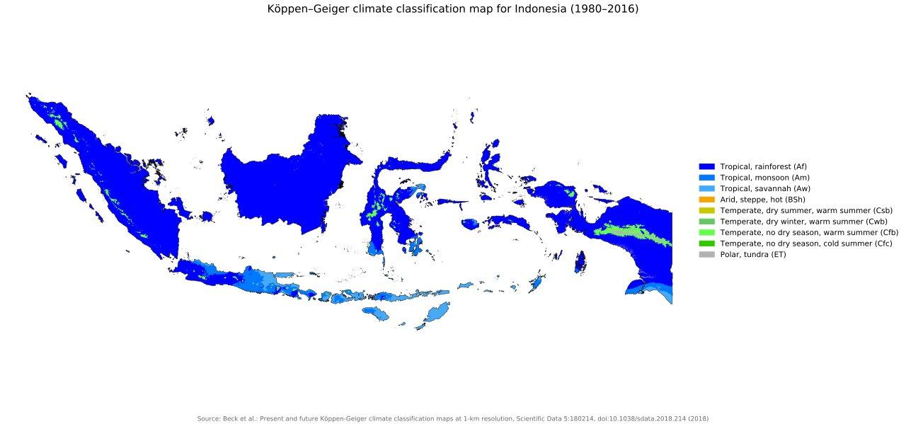
The Indonesia climate map shows average temperature and climate zones of Indonesia. This climate map of Indonesia will allow you to know weather, average precipitation, average sunshine and different climates of Indonesia in South Eastern Asia. The Indonesia climate map is downloadable in PDF, printable and free.
The climate of Indonesia is almost entirely tropical. The uniformly warm waters that make up 81 % of Indonesia area ensure that temperatures on land remain fairly constant, with the coastal plains averaging 28°C, the inland and mountain areas averaging 26 °C, and the higher mountain regions, 23 °C as you can see in Indonesia climate map. Temperature varies little from season to season, and Indonesia experiences relatively little change in the length of daylight hours from one season to the next; the difference between the longest day and the shortest day of the year is only forty-eight minutes. This allows crops to be grown all year round. The main variable of Indonesia climate is not temperature or air pressure, but rainfall. The area relative humidity ranges between 70 and 90%. Winds are moderate and generally predictable, with monsoons usually blowing in from the south and east in June through September and from the northwest in December through March. Typhoons and large scale storms pose little hazard to mariners in Indonesia waters; the major danger comes from swift currents in channels, such as the Lombok and Sape straits.
The extreme variations in rainfall are linked with the monsoons. Generally speaking, there is a dry season (June to September), influenced by the Australian continental air masses, and a rainy season (December to March) that is the result of mainland Asia and Pacific Ocean air masses. Local wind patterns, however, can greatly modify these general wind patterns, especially in the islands of central Maluku—Seram, Ambon, and Buru as its shown in Indonesia climate map. Prevailing wind patterns interact with local topographic conditions to produce significant variations in rainfall throughout the archipelago. In general, western and northern parts of Indonesia experience the most precipitation, since the north- and westward-moving monsoon clouds are heavy with moisture by the time they reach these more distant regions. Western Sumatra, Java, Bali, the interiors of Kalimantan, Sulawesi, and Papua are the most predictably damp regions of Indonesia, with rainfall measuring more than 2,000 millimeters per year.
Since 1990, mean annual temperature has increased by about 0.3°C. Although air temperature changes little from season to season or from one region to the next, cooler temperatures prevail at higher elevations. In general, temperatures drop approximately 1° per 90-meter increase in elevation from sea level with some high-altitude interior mountain regions experiencing night frosts as its mentioned in Indonesia climate map. The highest mountain ranges in Papua are permanently capped with snow. Being a tropical country, Indonesia does not have spring, summer, autumn, or winter, instead of just the two seasons of Rainy and Dry, both of which are relative. While there is significant regional variation, in most of the country (including Java and Bali) the dry season is April to October, while the wet season is November to March. However, global warming has made the seasons less predictable.