

You can find on this page the Indonesia region map to print and to download in PDF. The Indonesia political map presents states, regions, provinces and surrounding areas of Indonesia in South Eastern Asia.

The Indonesia regions map shows surrounding areas and provinces of Indonesia. This administrative map of Indonesia will allow you to know regions of Indonesia in South Eastern Asia. The Indonesia regions map is downloadable in PDF, printable and free.
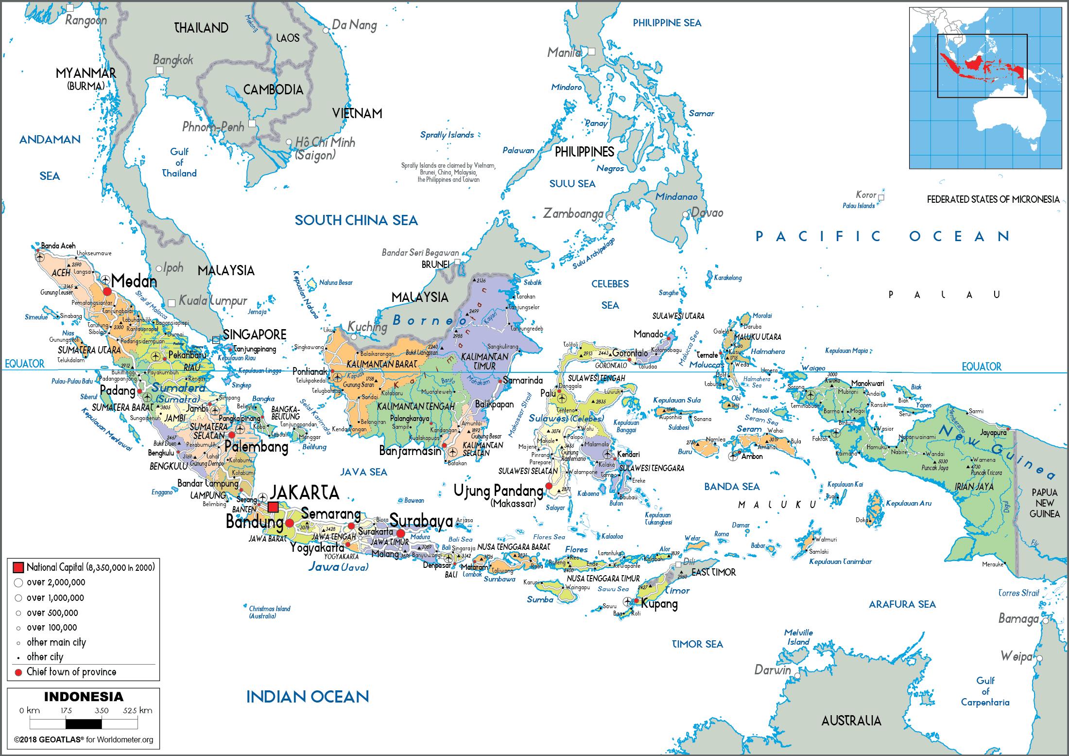
Java, the world most populous island, is a part of Indonesia. The island hosts about 145 million people that represent about 56.7% of the Indonesian population. Java is also home to Jakarta, the capital city of the country as its shown in Indonesia regions map. Formed by volcanism, Java is Indonesia fifth largest island by area. It has an area of 138,800 square km. The Indonesian part of Borneo is called Kalimantan. It has been divided into five administrative provinces and has a total area of 544,150.07 square km which represents about 73% of the area of the island. Kalimantan shares the island with a Malaysian state and the country of Brunei. Kalimantan has 15,894,524 residents. Kalimantan region is sparsely populated with large areas in the interior being covered by vast tracts of rainforest with a great diversity of flora and fauna.
The Maluku Islands is an Indonesian archipelago of around 1027 islands located in the Banda Sea as its mentioned in Indonesia regions map. Sulawesi and New Guinea are located to the west and east of the archipelago, respectively. This region is divided into two administrative provinces and hosts a population of around 2,844,131 residents. Ambon is the largest island in the archipelago in terms of population. The Lesser Sunda Islands are a group of islands located to the north of Australia where they are part of the Sunda Volcanic Arc in the Java Sea. Many of the islands in this group are top tourist destinations like Bali and Lombok. Most of these islands are politically a part of Indonesia. Three administrative provinces of Indonesia are located here. Many of the islands here are separated from their neighbors by deep oceanic trenches that have encouraged the evolution of endemic species independently on these islands.
The island of New Guinea is divided between two nations, Papua New Guinea and Indonesia. While the former lies entirely on the island, the latter has only two provinces as part of the island. Western New Guinea is the only part of Indonesia that is located in Oceania as you can see in Indonesia regions map. Some nearby islands are also a part of this territory. Most of the region is inhabited by various tribes and is covered by dense rainforests. With an area of 180,680.7 square km, Sulawesi is the world 11th largest island. Sulawesi has a population of 18,455,058 individuals. Politically, it is part of Indonesia and is divided into six administrative units. Sulawesi is located to the east of Borneo from which it is separated by the Strait of Makassar. Sumatra is the world sixth largest island and the largest one located entirely within Indonesian territory. The island covers an area of 473,481 square km. It has been divided into 10 administrative provinces. Its population has been estimated to be around 50,180,000 people.
The Indonesia political map shows regions and provinces of Indonesia. This administrative map of Indonesia will allow you to show regions, administrative borders and cities of Indonesia in South Eastern Asia. The Indonesia political map is downloadable in PDF, printable and free.
Politics of Indonesia takes place in a framework of a presidential representative democratic republic, whereby the President of Indonesia is both head of state and head of government, and of a multi-party system as you can see in Indonesia political map. Executive power is exercised by the government. Legislative power is vested in both the government and the two People Representative Councils. The judiciary is independent of the executive and the legislature. The 1945 constitution provided for a limited separation of executive, legislative, and judicial power. The governmental system has been described as "presidential with parliamentary characteristics." Following the Indonesian riots of May 1998 and the resignation of President Suharto, several political reforms were set in motion via amendments to the Constitution of Indonesia, which resulted in changes to all branches of government.
The General Election Committee (Indonesian: Komisi Pemilihan Umum, KPU ) is the body responsible for running both parliamentary and presidential elections in Indonesia. Prior to the General Election of 2004, the KPU was made up of members who were also members of political parties, however members of the KPU must now be non-partisan as its shown in Indonesia political map. The Indonesian Supreme Court (Indonesian: Mahkamah Agung) is the highest level of the judicial branch. Its judges are appointed by the president. The Constitutional Court rules on constitutional and political matters (Indonesian: Mahkamah Konstitusi), while a Judicial Commission (Indonesian: Komisi Yudisial) oversees the judges.
A constitutional reform process lasted from 1999 to 2002, with four constitutional amendments producing important changes. Among these are term limits of up to two five-year terms for the President and Vice President, and measures to institute checks and balances as its mentioned in Indonesia political map. The highest state institution is the People Consultative Assembly (MPR), whose functions previously included electing the president and vice president (since 2004 the president has been elected directly by the people), establishing broad guidelines of state policy, and amending the constitution. The 695-member MPR includes all 550 members of the People Representative Council (DPR) (the House of Representatives) plus 130 "regional representatives" elected by the twenty-six provincial parliaments and sixty-five appointed members from societal groups.

The Indonesia states map shows all departments and regions of Indonesia. States map of Indonesia will allow you to know areas and cities of Indonesia in Indonesia. The Indonesia states map is downloadable in PDF, printable and free.
The state (Indonesian: provinsi or propinsi) is the highest tier of local government subnational entity in Indonesia. Each state has its own local government, headed by a governor, and has its own legislative body. The governor and member of local representatives are elected by popular vote for five-year terms. With East Timor gaining its independence, Indonesia currently has 33 states, seven of which have been created since 1999 (North Maluku, West Papua, Banten, Bangka-Belitung Islands, Gorontalo, Riau Islands and West Sulawesi) and five states received special status as you can see in Indonesia states map: Aceh, for the use of the Sharia Law as the regional law of the state; Yogyakarta Special Region, for being governed in an ancient monarchy system; Papua, for implementation of sustainable development; West Papua, for granting implementation of sustainable development; and Jakarta Special Capital Region.
States are further divided into regencies (Indonesian: kabupaten) and cities. The states are officially grouped into seven geographical units. State (Indonesian: Provinsi) is headed by a governor. Each province has its own legislative body, called Dewan Perwakilan Rakyat Daerah (literally means "Regional People Representatives Assembly"). Governor and member of representatives are elected by popular vote for 5 years term. Among 33 provinces of Indonesia, 5 of them have special status as its shown in Indonesia states map: Nanggroe Aceh Darussalam (formerly: Aceh Special Region), has greater role in local government, such as has its own Islamic syari'ah law (only for Muslim citizen), flag and song of state, local political parties are allowed, and any decision or law made by central government which directly affect Aceh administration need to be consulted with the local government or legislative body. Yogyakarta Special Region, The Sultan of Yogyakarta is de facto governor of Yogyakarta since he is given priority when electing the governor. For centuries, Sultanate of Yogyakarta has reigned in the region.
Papua (formerly: Irian Jaya), since 2001 has greater role of local government, including allowed to use its own flag and song of state, and the governor is required to be Papuan origins. West Papua (formerly: Irian Jaya Barat), has an equal status with Papua. Jakarta Special Capital Region, is the capital city of Indonesia, and place of all national government bodies. The Governor of Jakarta has the power to appoint and dismiss the mayors and regent within Jakarta Special Capital Region. And the local government is allowed to have cooperation with other cities from other countries. Each state is divided into regencies and cities as its mentioned in Indonesia states map.