

You can find on this page the Indonesia road map to print and to download in PDF. The Indonesia driving map presents the detailed road network, main highways and free motorways of Indonesia in South Eastern Asia.
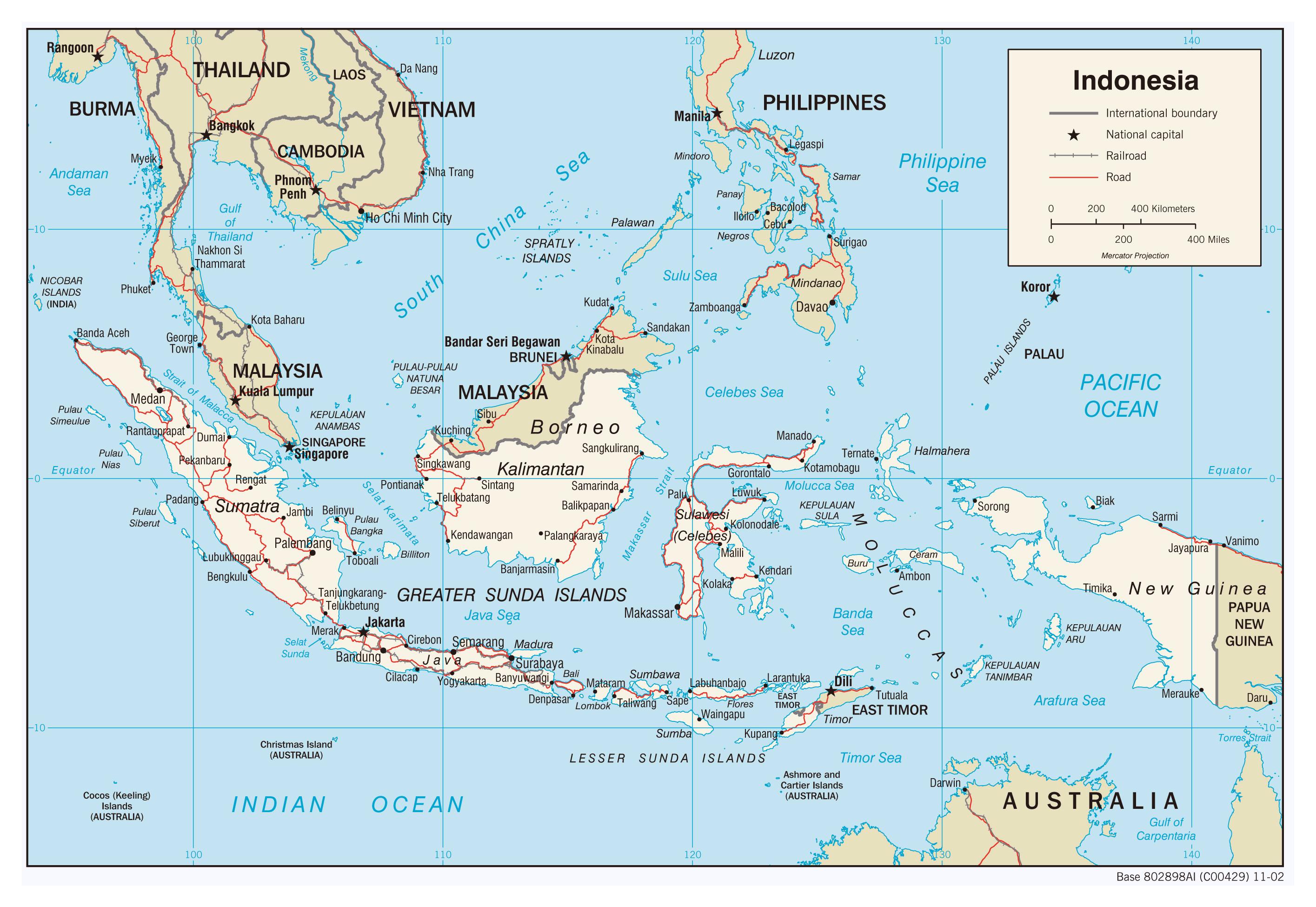
The Indonesia road map shows all roads network and main roads of Indonesia. This road map of Indonesia will allow you to preparing your routes and find your routes through the roads of Indonesia in South Eastern Asia. The Indonesia roads map is downloadable in PDF, printable and free.
A wide variety of vehicles are used for transportation on Indonesia roads. Bus services are available in most areas connected to the road network. In more remote areas, and between smaller towns, most services are provided with minibuses or minivans (angkut). Buses and vans are also the primary form of transportation within cities. Often, these are operated as share taxis, running semi-fixed routes. The national road network has not kept pace with growing demand, leading to a backlog of road network capacity. Although the length of the national road network has been extended by 3.7 percent annually over recent years, this is mostly due to the reclassification of existing roads, rather than the construction of new roads. In 2014, only 3 percent of additional national roads had been newly built, while 86 percent came from the reclassification of provincial roads. As a result, the current backlog of network capacity is estimated at about 17,000 lane-km of road space as you can see in Indonesia roads map.
Of the 342,700 km (121,954 mi) of roadways in 2002, 158,670 km (98,598 mi) were paved as its shown in Indonesia roads map. Indonesia had 526,300 passenger cars and 2,419,000 commercial vehicles as of 2001. Railways connect the main cities in Java and parts of Sumatra. The state owns all of the 6,458 km (4,013 mi) of railroad track in service. Air-conditioned cars and express service have been introduced in parts of Java, but no new lines have been built in recent years. . Between 2012 and 2017, national road transport demand grew by 8.7 percent per year to 134.9 billion vehicle-km per year. This outpaced average GDP growth of 5.3 percent per year during the period.
In 2020, the total length of city roads in Indonesia amounted to about 442.7 thousand kilometers, whereas the total length of all provincial roads amounted to approximately 54.8 thousand kilometers as its mentioned in Indonesia roads map. Based on the type of roads, city roads made up nearly 81 percent of the total distribution of the road network in Indonesia. National roads and expressways (i.e., roads managed by the central government) are strategically important to Indonesia productivity and competitiveness, carrying 40 percent of all traffic.
The Indonesia highway map shows toll and free motorways of Indonesia. This highways map of Indonesia will allow you to prepare your routes on motorways of Indonesia in South Eastern Asia. The Indonesia highway map is downloadable in PDF, printable and free.
AH25 highway of Indonesia consists of 4 parts, namely Jalan Raya Lintas Barat (Jalinbar), Jalan Raya Lintas Tengah (Jalinteng), Jalan Raya Lintas Timur (Jalintim), and Jalan Raya Lintas Pantai Timur as you can see in Indonesia highway map. Parts of it are being set up for toll roads. Medan-Binjai Toll Road is 20.5 km long and set to open between 2005 and 2010. Major cities linked by the roads: Jalinbar (West): Padang Panjang, Padang, Painan, Bengkulu, and parts of Lampung province. Jalinteng (Central) : Medan, Bukit Tinggi, Pematang Siantar, Parapat, Tarutung, Padang Sidempuan, Bonjol, Bukittinggi, Singkarak, Bandar Jaya and Bandar Lampung, Jalintim (East) : Banda Aceh, Lhokseumawe, Langsa, Pangkalan Berandan, Binjai, Medan, Lima Puluh, Kisaran, Rantau Prapat, Pekanbaru, Pangkalan Kerinci, Jambi, Palembang, Indralaya, Bandar Jaya.
Indonesia has some highways, some of them are National Routes (25, currently only in Java), and some of them are freeways. All the freeways are tolled (toll road). The most expensive is the Cipularang Toll road that connects Jakarta and Bandung. Due to the increasing purchasing power of Indonesians, private cars are becoming more common especially in major cities. However the growth of the number of cars increasingly outpaces the construction of new roads, resulting in frequently crippling traffic jams in large parts in major cities especially in Jakarta, which often also happen on highways. The AH2 highway is one of Indonesia main highways. The other one is AH25 in Sumatra as its shown in Indonesia highway map. Indonesia has about 213,649 km of paved highways and about 154,711 km of unpaved highways (As of 2002 estimate).
The AH2 (AH 2) is a road in the Asian Highway Network running 8230 miles (13,177 km) from Denpasar, Indonesia to Khosravi, Iran as its mentioned in Indonesia highway map. The Trans-Sumatran Highway is a primarily north-south road in the Indonesian island of Sumatra, 2,508.5 km long, and connecting the north of the island in Banda Aceh to Bandar Lampung in the south, running through many major cities, including Medan and Padang on the way. The road is a major artery, carrying transmigrants (see transmigrasi) from Java to the less densely populated Sumatra, and carrying Sumatran visitors to Jakarta and Java. The Trans-Sumatran Highway forms the whole section of the Asian Highway Network route AH25 AH25. Indonesia key Trans-Sumatra highway project will be complete in 2024.